About HAZMAT Evac
HAZMAT Evac provides First Responders and Emergency Managers easy access to map-based improvised explosive device (IED) standoff distances and HAZMAT spill evacuation areas. The IED standoff data is based on criteria set...
HAZMAT Evac provides First Responders and Emergency Managers easy access to map-based improvised explosive device (IED) standoff distances and HAZMAT spill evacuation areas. The IED standoff data is based on criteria set by the DHS Office for Bombing Prevention and FEMA 426, Reference Manual to Mitigate Potential Terrorist Attacks Against Buildings. Hazmat evacuation and reference data is based on the 2012 Emergency Response Guidebook (ERG). Users are able to define custom IED types and standoff values. Access to DHS IED standoff data requires a statement of need by those not registering with a .mil, .gov, or .us email address accounts.
Features of the software include:
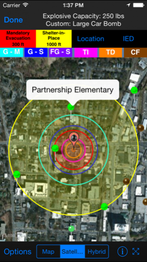
•Display IED Mandatory Evacuation and Shelter-in-Place Zones for 8 pre-defined bomb sizes
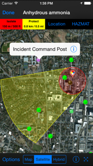
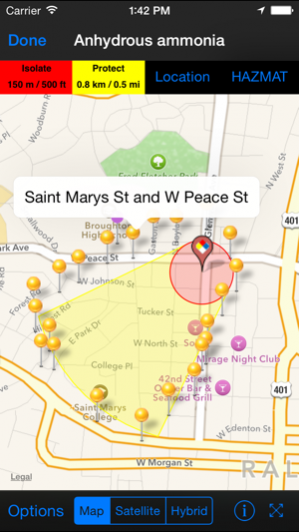
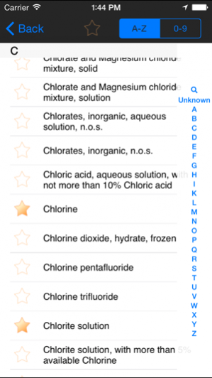
•Display Isolation Zones and down-wind Protection Zones for over 3,000 chemicals
•Display distance to glass breakage, injury, and structural damage based on pre-defined bomb sizes (limited to users registering with a .gov, .mil, or .us email)
•Information displayed on phone maps, with similar functionality to zoom, search by address, current location, and map/satellite/hybrid views
•Automatically retrieve current weather from Weatherbug (www.weather.weatherbug.com) or forecast weather from the National Weather Service (US only) or Meteorologisk Institutt (Worldwide); weather can also be user input or input using the phone’s compass functionality
•Results shown geographically as well as text based
•Search and display predefined points of interest (schools, nurseries, hospitals, police/fire stations, and government facilities) from GIS search services to identify key facilities within the incident area
•Run roadblock analysis service that identifies within seconds the optimal location of roadblocks to isolate the incident area
•Place and label points on the map to identify key locations
•One-button summary of results (text, map image, map data shape and kml file attachments) in an email to disseminate to other responding personnel
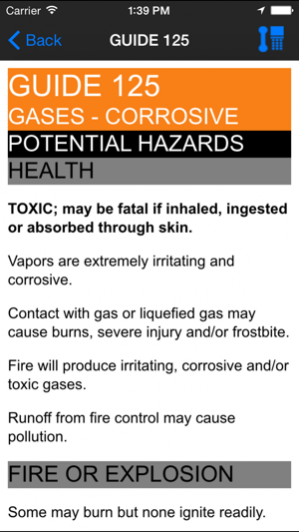
•Includes reference material from the 2012 ERG and important chemical contacts for quick calling
•Store map images (including legends) for reference when connectivity prevents access to network maps
For more information, go to www.firstsupporttools.com
Sep 19, 2017 Version 4.2
This app has been updated by Apple to display the Apple Watch app icon.
- Roadblock dialog enhanced for better clarity
- Roadblock isolation distances available on map
- Added table displaying all roadblocks
- Fixed bug for including images to incidents posted to the FiRST Sharing Service
- Fixed bug with display of saved images (Capture Map)
Previous Versions
Here you can find the changelog of HAZMAT Evac since it was posted on our website on 2016-09-25 15:33:07.
The latest version is 4.2 and it was updated on 2024-03-29 17:59:38. See below the changes in each version.
HAZMAT Evac version 4.2
Updated At: 2017-09-19
Changes: Sep 19, 2017 Version 4.2
This app has been updated by Apple to display the Apple Watch app icon.
- Roadblock dialog enhanced for better clarity
- Roadblock isolation distances available on map
- Added table displaying all roadblocks
- Fixed bug for including images to incidents posted to the FiRST Sharing Service
- Fixed bug with display of saved images (Capture Map)
HAZMAT Evac version 4.2
Updated At: 2017-09-19
Changes: Sep 19, 2017 Version 4.2
This app has been updated by Apple to use the latest Apple signing certificate.
- Roadblock dialog enhanced for better clarity
- Roadblock isolation distances available on map
- Added table displaying all roadblocks
- Fixed bug for including images to incidents posted to the FiRST Sharing Service
- Fixed bug with display of saved images (Capture Map)
HAZMAT Evac version 4.2
Updated At: 2017-09-19
Changes: Sep 19, 2017 Version 4.2
- Roadblock dialog enhanced for better clarity
- Roadblock isolation distances available on map
- Added table displaying all roadblocks
- Fixed bug for including images to incidents posted to the FiRST Sharing Service
- Fixed bug with display of saved images (Capture Map)
HAZMAT Evac version 3.31
Updated At: 2011-01-11
HAZMAT Evac version 4.2
Updated At: 1970-01-01
Changes: 2017年9月19日 Version 4.2
- Roadblock dialog enhanced for better clarity
- Roadblock isolation distances available on map
- Added table displaying all roadblocks
- Fixed bug for including images to incidents posted to the FiRST Sharing Service
- Fixed bug with display of saved images (Capture Map)
HAZMAT Evac version 4.2
Updated At: 1970-01-01
Changes: 2017년 9월 19일 Version 4.2
- Roadblock dialog enhanced for better clarity
- Roadblock isolation distances available on map
- Added table displaying all roadblocks
- Fixed bug for including images to incidents posted to the FiRST Sharing Service
- Fixed bug with display of saved images (Capture Map)
Disclaimer
Official App Store Link
We do not host HAZMAT Evac on our servers. We did not scan it for viruses, adware, spyware or other type of malware. This app is hosted by Apple and passed their terms and conditions to be listed there. We recommend caution when installing it.
The App Store link for HAZMAT Evac is provided to you by apps112.com without any warranties, representations or guarantees of any kind, so access it at your own risk.
If you have questions regarding this particular app contact the publisher directly. For questions about the functionalities of apps112.com contact us.